Created by land managers, for land managers, ECO:SENSE is a GIS-based classification and detection tool that transforms UAV survey data into high-resolution, actionable insights that can assist in the digital ecology workflow.
THE DATA YOU NEED
Get advanced data and metrics for improved management outcomes
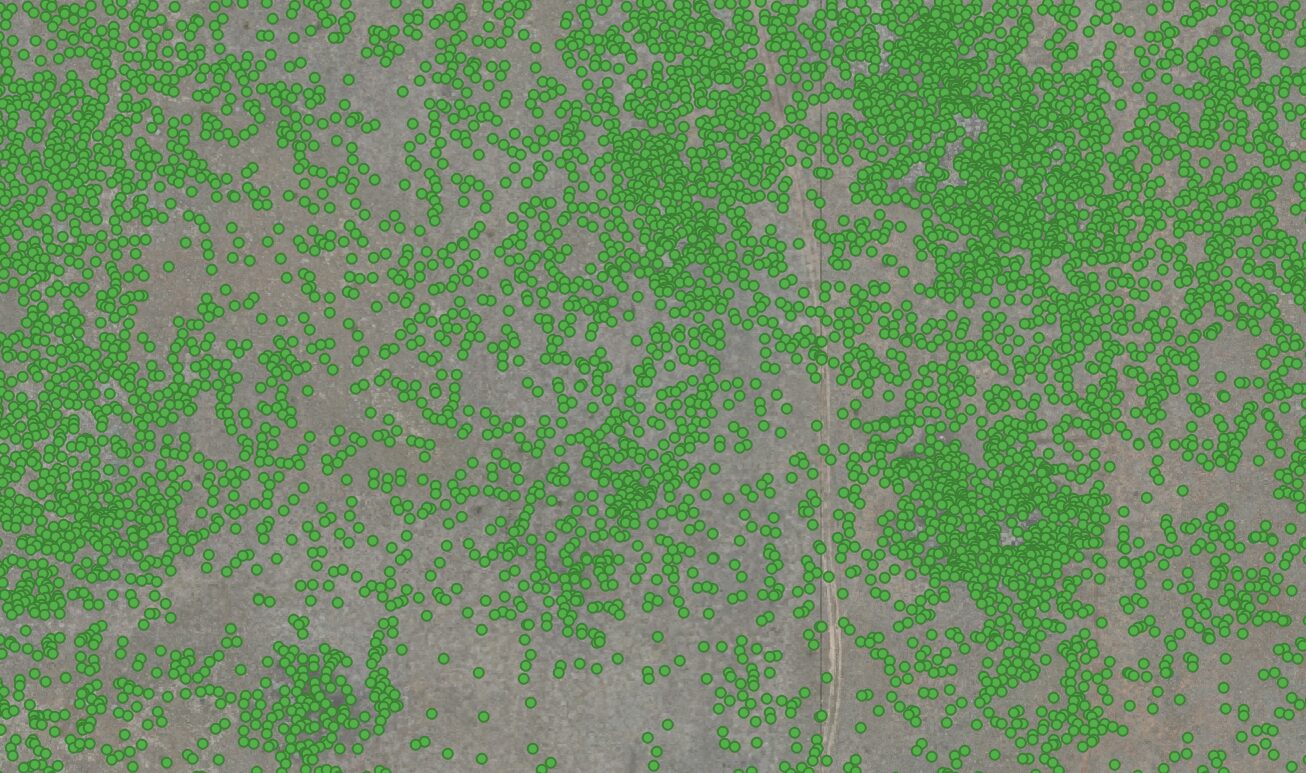
ECO:SENSE streamlines vegetation monitoring by automating species detection and generating spatial metrics such as abundance, distribution, and average plant size. By increasing survey efficiencies with precision-based accuracy, ECO:SENSE supports better decision-making, targeted reporting, and more efficient use of resources, allowing land managers to focus on priority areas and put more boots on the ground where they are most needed.
OUTCOME DRIVEN DATA WITH INTEGRITY
ECO:SENSE provides an integrated management solution that creates high resolution data for use in management, landscape assessment and long term reporting and assessment
The ECO:SENSE classification tool is designed to turn high-resolution drone imagery into actionable insights. It streamlines large-scale vegetation and weed monitoring, helping land managers identify, quantify, and respond to situations efficiently. Our ECO:SENSE tool assists land managers to:
Automate weed and plant detection and classification across large landscapes
Produce detailed maps for rapid identification and analysis. Reduce manual survey efforts, increase accuracy in data metrics, provide greater decision-making assistance and allow more resources to flow into ground works with greater efficiency
Support vegetation management decisions with spatial outputs and metrics in abundance, distribution and surface cover
Enable researchers, ecologists, and land managers to build, refine, and deploy trained models tailored to specific species and environments
Provide accurate data for reporting and assessment of metrics such as attrition, treatment efficacy and progression over time
DOWNLOAD OUR ECO:SENSE INFO SHEET for more information
Firetail Environments offers other services and skills around its focus on drone surveys and environmental analysis. These expanded offerings draw on the skills and experience of the Firetail team and provide services complimentary to its specialised drone surveying. Other services include:
Training & Workshops for professionals – Training programs for professionals adopting or integrating UAV technology into their processes including courses in photogrammetry, multispectral, DJI Agras workflows and more.
Ecological consultation, on-ground surveys and on-ground works – Services in on-ground surveys and on-ground works crews including tree planting, terrestrial weed spraying, environmental monitoring and other solution based on-ground services.
Carbon, EG&S and Nature Repair – Assistance and advice in designing, planning and delivering EG&S projects in carbon and landscape or biodiversity repair including strategic carbon, biodiversity and emissions consultation.
Regenerative agriculture support & consultation – Planning and project consultation in regenerative agriculture including designing for increased biodiversity, cover cropping & rotational grazing, silvopasture and forestry systems.
Get in touch...
Firetail Environments is a premier and specialist UAV operator based in Central Victoria