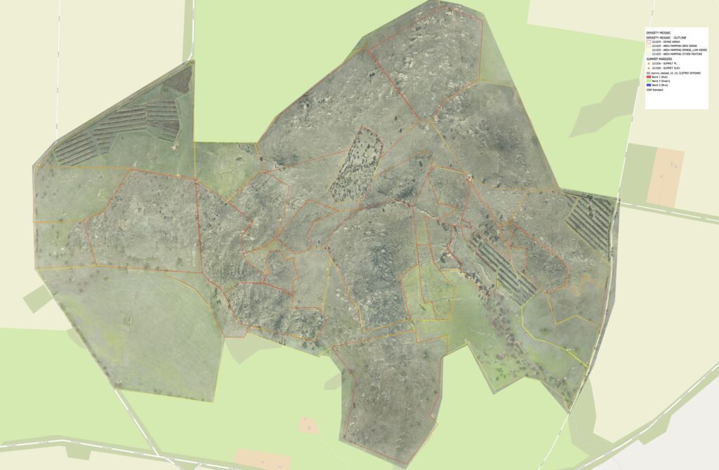
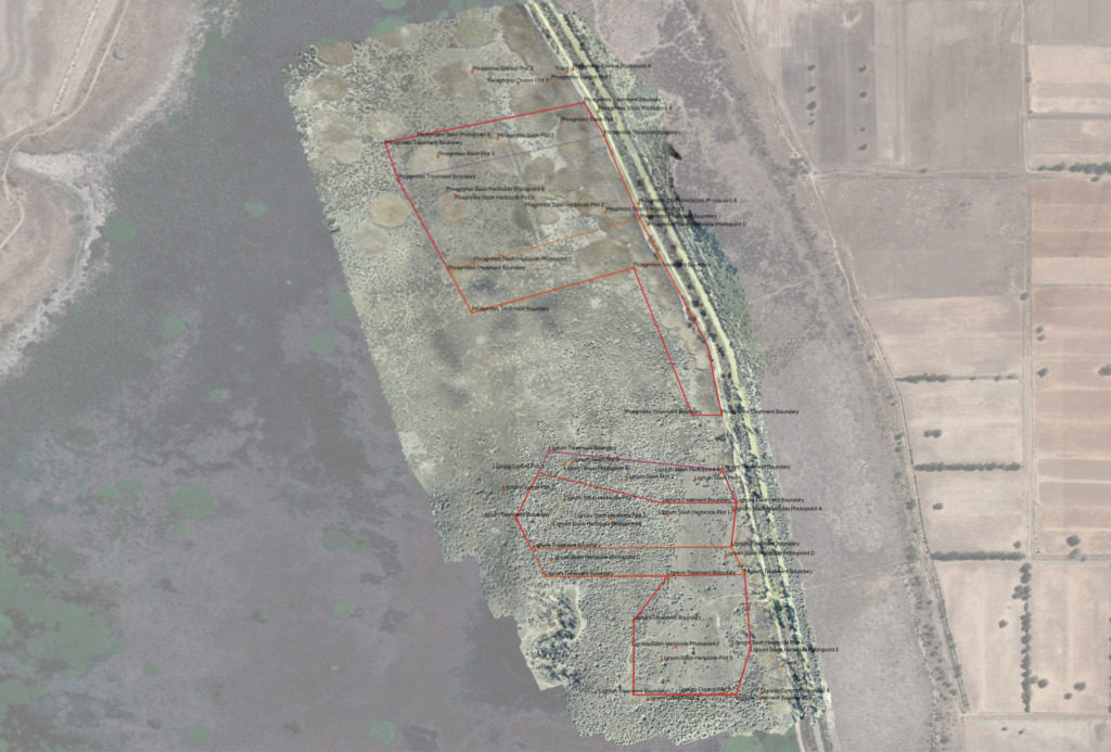
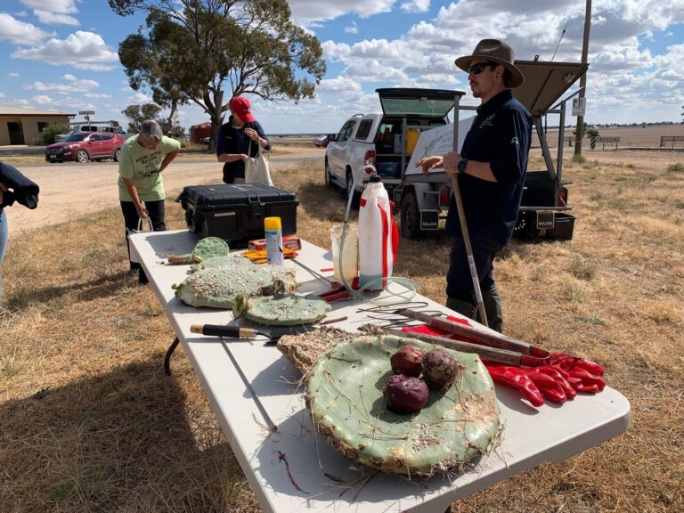
Client : Djaara . Bush Heritage Australia . Loddon Plains Landcare Network Scope : Aerial mapping and landscape assessment of Wheel Cactus (Opuntia robusta) at Mt Buckrabanyule in central Victoria.
Firetail Environments has been engaged on the project to undertake high resolution mapping services for RGB and multispectral mapping of the property to provide better data and resources to combat invasive Wheel Cactus on the property and across the area.
An aerial survey was conducted and mapping developed to assess density by area, provide highly detailed maps for landscape assessment, and plant health was assessed to better understand treatment options for the property.
This project forms part of a Traditional Owner led program to eradicate Wheel Cactus from the 300+ hectare property and works with Djaara Traditional Owners, Bush Heritage Australia and the community to advance control techniques for Wheel Cactus in central Victoria.
Wheel Cactus Management Plan, Mt Buckrabanyule
Client : Djaara . Bush Heritage Australia . Loddon Plains Landcare Network Scope : Develop a comprehensive management plan Mt Buckrabanyule to efficiently manage and work towards the eradication of Wheel Cactus on the property.
Firetail Environments is currently working with Djaara Traditional Owners, BHA, LPLN and other stakeholders to develop a control program for Wheel Cactus at Mt Buckrabanyule in central Victoria.
The Plan will inform management actions, research and trials at the property to undertake appropriate management of Opuntia robusta, with an intention to have findings adopted more broadly across the region.
Pale Yellow Water Lily monitoring
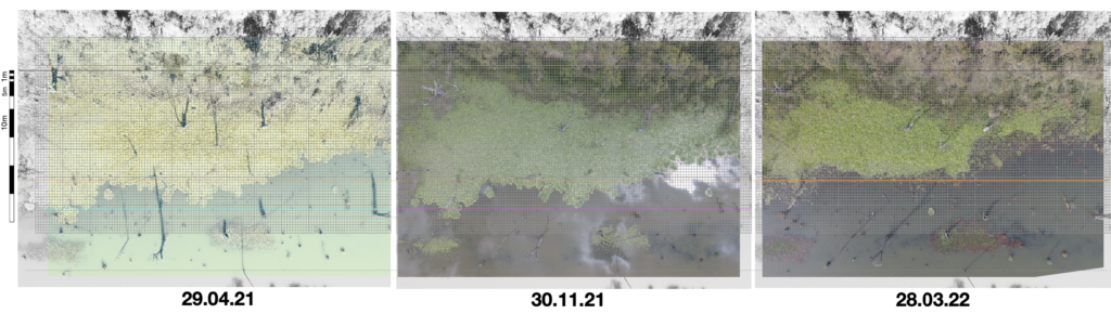
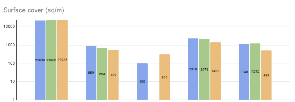
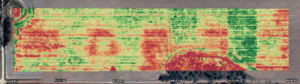
Client : North Central CMA Scope : Conduct drone surveying on five sites treated for Pale Yellow Water Lily, creating mapping and control efficiency report for current treatment program
Firetail Environments is currently working with North Central CMA on mapping the efficiency of control of Pale Yellow Water Lily on Gunbower Creek.
This project takes in five sites controlled for the invasive weed, collecting detailed mapping and plant health data twice per year – before and after treatment. This data is processed and reporting is generated on the findings including treatment efficiencies, regrowth on water surface, plant health and increases or decreases of biomass over time.
The project has been running since 2021 and will continue through to 2024, with findings updated seasonally in order to provide details for the next treatment period.
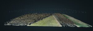
Johnston Swamp
Client : North Central CMA Scope : Conduct drone surveying at Johnston Swamp to provide base line data on treatment efficiencies on Phragmites and Tangled Lignum (Trial)
Firetail Environments is currently working with North Central CMA on mapping the efficiency of control of Phragmites and Tangled Lignum at Johnston Swamp in the north of Victoria.
This project has provided baseline data on different treatments, to better understand regrowth and treatment efficiencies in order to provide improved management actions for migratory birds and waders.
Prescription mapping was produced, and sites assessed via detailed GIS analysis, providing a baseline for future activities.
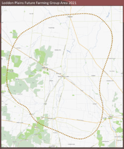
Loddon Plains Future Farming Regen Ag Group
Client : Loddon Plains Landcare Network Scope : Facilitate, provide consultation and conduct soil testing for Loddon Plains Future Farmers Regenerative Agriculture Group.
Firetail Environments is the facilitator of this group, providing events and workshops in regenerative agriculture practices for the Loddon Plains community.
The project also includes delivering an on ground soil collection program for members and farmers in the area.
Bendigo Tafe Drone Program
Client : Bendigo Kangan Institute Scope : Oversee Bendigo Tafe drone program and drone collection activities for Conservation and Agriculture courses.
Firetail Environments currently works with Bendigo Tafe overseeing its drone program and extensive drone fleet.
The program works with staff and students to undertake appropriate flights and delivers detailed workshops in contextualising data and understanding its application in land stewardship and farming applications.
Workshops
Owner, Danny Pettingill, is a popular industry presenter and has presented to a number of community groups and organisations.
He has been a favourite presenter at the National Landcare Conference, Wimmera Biodiversity Seminar, Victorian Weeds Conference and other events across Victoria and Australia.
Danny presents specialised workshops and field days in:
Carbon projects for farming and biodiversity
Biodiversity and Landscape function (Reading Landscapes)
Drone programs for conservation and farming
GIS and Mapping inc. open source platforms, Atlas of Living Australia etc.
Leadership
Strategy and project design
Wheel Cactus
If you would like to engage Danny in these services, get in touch via the contact page.